From a distance of 500 kilometers out in space, two German satellites equipped with special scanners are making a 3D map of the Earth's surface within an astounding accuracy of just two meters.
They are the perfect pair – the TerraSAR-X and TanDEM-X satellites orbiting Earth in a tight formation 15 times a day.
The satellites, each slightly larger than a Volkswagen Golf, are circling 500 kilometers above the planet only a few hundred meters apart.
In tandem, they are examining the Earth's surface with radar pulses, each generating separate data that is later combined, explains Alberto Moreira, director at the Institute of Technology and Radar Systems at the German Aerospace Center (DLR) in Oberpfaffenhofen.
Tight flight formation
"We have developed a technology that allows two radar systems to fly in tight formation and produce a three-dimensional image of the Earth's surface," Moreira says
 Many organizations are interested in 3D Earth data
Never before have engineers been able to coordinate the trajectory of the satellites to keep them from being too close or too far away from each other to generate the targeted data.
Through different perspectives, the two satellites capture the Earth's terrain in 3D, in much the same way our two eyes allow for spatial vision.
"The entire land mass of the Earth's surface - about 150 million square kilometres - is completely mapped twice," says Manfred Zink, TanDEM-X Project Manager at DLR in Oberpfaffenhofen.
Patchwork process
Each of the radar systems maps an area that is typically 20 by 40 kilometers in edge length, gradually covering the Earth's entire surface in a patchwork process.
The project is to be completed by the end of next year, according to Zink. "We need six more months to capture mountainous areas and steep terrain," he notes.
The TerraSAR-X and TanDEM-X satellites, built by the Center for Air and Space travel at Astrium in Friedrichshafen, have been orbiting Earth since 2007 and 2010 respectively. "The advantage of using radar is simple - you aren't not restricted by cloud cover and lightning conditions," says Eckard Settelmeyer, Astrium's Director of Earth Observation and Science.
Whether light or dark, clear or cloudy, the satellites always have the Earth in perfect view. They keep working when other observation satellites are forced to cease operation due to darkness or fog.
Digital elevation model
The engineers are targeting a precision that no one dared dream of until now, according to Zink. "The goal of the TanDEM-X mission is a homogenous global digital elevation model," he says.
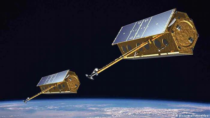 The satellites: TanDEM-X and TerraSAR-X
That means plenty of work for the scientists and engineers. The analysis of the radar's data is extremely complex. In addition, the satellites' trajectories must be accurate, to the millimeter, while calculated at a speed of more than 27,000 kilometers per hour.
But the work, the team members agree, is well worth the effort: they're producing the first high-precision 3D globe.
The collected data can be used in many ways, such as urban and landscape planning, navigation, construction of transmission lines for electricity, oil and gas or operational planning in disaster areas.
New perspective of Earth
It will also enable scientists to explore glaciers, earthquakes and volcanic areas, among others, and is of particular interest to the military.
The orbiting "eyes" give Zink and his team an entirely new perspective of the Earth. "TanDEM-X is a unique combination of scientific and technical challenges and a product that is going to affect all of humanity," he says
Because of its commercial potential, the TanDEM-X mission was launched from the start as a public-private partnership. The aerospace company Astrium funded a quarter of the 200-million-euro project in return for the commercial rights to the radar data.
Given the huge interest in the data, the TanDEM-X team is already considering a new mission. dw de

No comments:
Post a Comment